The skill sets and professional capabilities of a hotel management graduate fit in really well…

Meghalaya Tourism

Earlier, foreign tourists required special permits to enter the areas that now constitute the state of Meghalaya. However, the restrictions were removed in 1955. Meghalaya is compared to Scotland for its highlands, fog and scenery. Meghalaya has some of the thickest primary forests in the country and therefore constitutes one of the most important ecotourism circuits in India. The Meghalayan subtropical forests support a vast variety of flora and fauna. Meghalaya has 2 National Parks and 3 Wildlife Sanctuaries.
Meghalaya also offers many adventure tourism opportunities in the form of mountaineering, rock climbing, trekking and hiking, caving (spelunking) and water sports. The state offers several trekking routes, some of which also afford an opportunity to encounter rare animals. The Umiam Lake has a water sports complex with facilities such as rowboats, paddleboats, sailing boats, cruise-boats, water-scooters and speedboats.
Cherrapunji is one of the popular tourist locations in north-east of India. The town is well known and has guided tours of Tree Root Bridges. It lies to the south of the capital Shillong. A rather scenic 50 kilometre long road connects Cherrapunji with Shillong.
Waterfalls and rivers
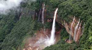
The popular waterfalls in the state are the Elephant Falls, Shadthum Falls, Weinia falls, Bishop Falls, Nohkalikai Falls, Langshiang Falls and Sweet Falls. The hot springs at Jakrem near Mawsynram are believed to have curative and medicinal properties.
Nongkhnum Island located in the West Khasi Hills district is the biggest river island in Meghalaya and the second biggest in Asia. It is 14 kilometres from Nongstoin. The island is formed by the bifurcation of Kynshi River into the Phanliang River and the Namliang River. Adjacent to the sandy beach the Phanliang River forms a very beautiful lake. The river then moves along and before reaching a deep gorge, forms a pretty waterfall about 60 meters high called Shadthum Fall.
Sacred groves
Meghalaya is also known for its “sacred groves”. They are small or large areas of forests or natural vegetation that are usually dedicated to local folk deities or tree spirits or some religious symbolism over many generations, often since ancient times. These spaces are found all over India, are protected by local communities, and in some cases the locals would neither touch leaves or fruits or in other ways damage the forest, flora or fauna taking refuge in them. This guardianship creates a sacred area where nature and wildlife thrive. The Mawphlang sacred forest, also known as “Law Lyngdoh,” is one of the most famous sacred forests in Meghalaya. It’s located about 25 kilometres from Shillong. It’s a scenic nature destination.
Rural areas
Meghalaya rural life and villages offer a glimpse in northeast mountain life. The Mawlynnong village located near the India-Bangladesh border is one such village. It has been featured by travel magazine Discover India. The village is geared for tourism and has a Living Root Bridges, hiking trails and rock formations.
Lakes
Meghalaya also has many natural and manmade lakes. The Umiam Lake (popularly known as Bara Pani meaning Big water) on the Guwahati-Shillong road is a major tourism attraction for tourist. Meghalaya has several parks; Thangkharang Park, the Eco-park, the Botanical Garden and Lady Hydari Park to name a few. Dawki, which is located at about 96 Kilometres from Shillong is the gateway to Bangladesh and affords a scenic view of some of the tallest mountain ranges in Meghalaya and the Bangladesh border lands.
Balpakram National Park with its pristine habitat and scenery is a major attraction. The Nokrek National Park, also in Garo Hills has its own charm with lot of wildlife.
Caves
Meghalaya has an estimated 500 natural limestone and sandstone caves spread over the entire state including most of the longest and deepest caves in the sub-continent. Krem Liat Prah is the longest cave, and Synrang Pamiang is the deepest cave. Both are located in the Jaintia Hills. Cavers from United Kingdom, Germany, Austria, Ireland and the United States have been visiting Meghalaya for over a decade exploring these caves. Not many of these have however been developed or promoted adequately for major tourist destinations.
- Jakrem: 64 km from Shillong, a potential health resort having gushing hot-spring of sulphur water, believed to have curative medicinal properties.
- Ranikor: 140 km from Shillong, a place of scenic beauty. Ranikor is one of Meghalaya’s most popular spots for angling, with an abundance of carp and other fresh water fish.
- Dawki: 96 km from Shillong, is a border town, where one can have a glimpse of the neighbouring country of Bangladesh. The colourful annual boat race during spring at the Umngot river is an added attraction.
- Kshaid Dain Thlen Falls: Located near Sohra, meaning the falls where the mythical monster of Khasi legend was finally butchered. The axe-marks made on the rocks where Thlen was butchered are stillintact and visible..
- Diengiei Peak: Located to the west of the Shillong plateau, Diengiei Peak is just 200 feet lower than Shillong peak. On the top of Diengiei, there is a huge hollow, shaped like a cup, believed to be the crater of an extinct pre-historic volcano.
- Dwarksuid: A beautiful pool with wide, rocky sand banks located on a stream alongside the Umroi-Bhoilymbong Road is known as Dwarksuid or Devil’s doorway.
- Kyllang Rock: Located about 11 kilometres off Mairang, is a several million years old steep dome of red granite rising to an elevation of about 5400 feet above sea level.
- Sacred Forest Mawphlang: One of the most celebrated sacred-groves of the State is the grove at Mawphlang about 25 kilometres off Shillong. Preserved since time immemorial, these sacred groveshave wide range of flora, thick cushion of humus on the grounds accumulated over the centuries, and trees heavily loaded with epiphytic growth of aroids, pipers, ferns, fern-allies and orchids.


